

How a network of concrete is starving the Cauvery Delta and rewriting the geological laws of South India
Imagine a river not just as a flow of water, but carrying the sediment and rock that shape its course, nourish its delta, and sustain its ecosystems. The distribution of this sediment is being dramatically altered not by earthquakes or ancient geological shifts, but by human hands. In a recently published study focusing on South India’s Cauvery River, we showed in facr that massive dams have become the single most powerful force controlling the river’s sediment, overriding the natural drivers that have shaped the basin for millennia.

For centuries, intense monsoon rains, steep slopes of the Western Ghats, and the mature, weathered landscape all played their parts in determining how much sediment was washed into the ocean. But our research, analyzing decades of data from 19 sub-basins, reveals a new, human-dominated chapter. The clearest signal in the data is an anthropogenic one which is the footprint of dams. We found that the area covered by reservoirs alone explains a staggering 41% of all variation in sediment yield across the basin. In five sub-catchments, the effect is so extreme that the sediment yield is negative, meaning more sediment is permanently trapped behind dams. This is a definitive human signature, turning parts of the river system from sediment exporters into net storage sinks.
This doesn’t mean nature’s role has vanished. Rainfall remains the primary natural driver, its intense orographic pattern directly controlling erosion. But its influence is now mediated by the dams humans have built. Furthermore, we uncovered a crucial “dilution effect”: larger catchments naturally store more sediment in floodplains and valleys, leading to lower sediment yields. This natural scaling law is now amplified by dams, which act as super-efficient sediment traps at strategic points, severing the connection between erosion in the headwaters and delivery to the coast.
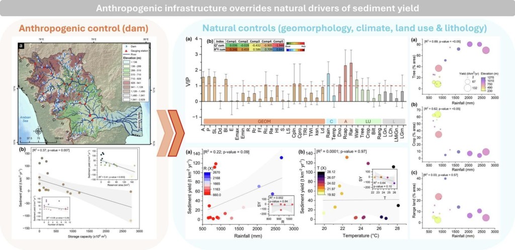
One of the most surprising findings challenges conventional wisdom about land use. We often assume forests are universal guardians against erosion. In the Cauvery basin, however, some of the highest sediment yields come from densely forested, high-elevation areas. Why? Because these forests sit in the path of some of the most extreme rainfall on the planet, on steep, rugged slopes. Here, the sheer energy of monsoonal deluges can overpower the soil-stabilizing effect of roots, triggering saturated overland flow that mobilize weathered material from beneath the canopy. Conversely, agricultural lands in the drier eastern plains export less sediment, not because they are less erosive, but because there’s less rainfall energy to move the sediment. The influence of land use, therefore, is entirely dependent on its underlying geography and climate.
The implications are vast. The Cauvery’s delta is already starving for sediment and retreating, a direct consequence of upstream trapping. Our findings provide a transferable framework for understanding sediment dynamics in regulated rivers worldwide. They tell us that sustainable water resource management must urgently account for sediment continuity. Planning for hydropower and irrigation can no longer ignore the downstream geological consequences. Mitigating reservoir siltation and designing targeted erosion control requires understanding this new hierarchy of controls, where human infrastructure sits firmly at the top.
Read our article: Das, S., Talukdar, S., Scaringi, G., 2026. Anthropogenic infrastructure overrides natural drivers of sediment yield in a major monsoonal river basin. Science of the Total Environment (link).
